Scenic Drives in the Smokies
A bridge on the Roaring Fork Motor Nature Trail.
Auto-touring has grown rapidly in the past several years. Driving down scenic highways is just about as American as it gets.
Whether you’re just going to the visitor center, exploring a waterfall, finding a trailhead, or simply country cruising the mountainous roads, the the Great Smoky Mountains National Park is a great place to enjoy an afternoon drive.
Our favorite time of the year to take a scenic drive in the Smokies is undoubtedly the fall. Unbelievable fall colors explode throughout the hills and valleys.
The national park offers a multitude of scenic roads to explore – nearly 384 miles worth, to be exact! Here are some of the most popular scenic drives around the Smoky Mountains.
Note: Some of these roads are closed during the winter months.
You can find out more information in our Cades Cove section of Smokies Adventure.
Cove Creek Road
The easiest way for motorists to get to the Catalooche Valley is Cove Creek Road. This 11-mile gravel road winds and turns through the mountains to make the Cataloochee Valley accessible. There are no guard rails, and the road is very narrow. If you have a large vehicle, you might run into some trouble.
The valley is surrounded by high peaks, but the fertile land at the bottom provided early settlers with a place to live. People come to the Cataloochee Valley to see historic 19th century buildings, including a lone chapel. Wildlife viewing is also abundant in the valley, especially in the mornings and afternoons
Clingmans Dome Road
This 7-mile side road off of Newfound Gap Road takes visitors to the top of Clingmans Dome. Clingmans is the highest peak in Tennessee and also the highest peak along the Appalachian Trail. The road ends at the parking lot for Clingmans Dome. From there, it is a half-mile hike to the observation tower.
Little River Road
This 18-mile, curvy road connects Gatlinburg, at Sugarlands Visitor Center, with Townsend. Most people use this road to access popular sites such as Cades Cove, Elkmont Campground, Greenbrier School, Laurel Falls, and Tremont.
Newfound Gap Road
The quickest way into North Carolina from Gatlinburg is the Newfound Gap Road (US Highway 441). This 33-mile, paved mountainous road climbs all the way up to Newfound Gap, 5,048 feet above sea level. Newfound Gap Road offers several pull-offs with mountainous panoramic views.
It usually takes approximately one hour to get from Gatlinburg to Cherokee, so be prepared for a long drive. At the top of Newfound Gap, there is a huge parking lot with restrooms. Visitors usually stop here on top of the ridge to view the wondrous scenery and spruce forest.
One interesting monument is located there – the Rockefeller Memorial, in appreciation of the family’s donations, which were instrumental in the creation of more than half the Great Smoky Mountains National Park. This site was also where Franklin D. Roosevelt spoke to inaugurate the park on September 2, 1940.
Access to the Appalachian Trail is also provided here, since the trail literally has its own crosswalk through the parking lot (so you can expect to see some hikers). This road was originally planned to wind up Bote Mountain and up to where Spence Field is located today. After having a difficult time constructing the road, planners decided to move it to where it is now, giving it the name Newfound Gap.
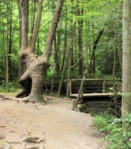
Roaring Fork Motor Nature Trail
The Roaring Fork Motor Nature Trail is a 6-mile, one-way, loop road that is paved. It is the closest motor vehicle trail to Gatlinburg, Tennessee. Visitors can access the Roaring Fork Motor Nature Trail by turning onto Historic Nature Trail Road at Gatlinburg traffic light #8 and taking the road all the way to the Cherokee Orchard entrance. Busses, trailers, and RVs are not allowed on the motor trail.
Highlights of the trail include wildlife viewing, log cabins, and streams. One of the most popular waterfalls in the park can be accessed by taking Rainbow Falls Trail. It is a 5.4-mile hike to Rainbow Falls and back. Bring a lot of water and snacks if you plan to hike to Rainbow Falls.
This scenic drive is a must and is highly recommended by Smokies Adventure!
Tremont Road
Veering off of Little River Road, Tremont Road runs parallel with the Middle Prong up to Walker Valley. The Great Smoky Mountains Institute at Tremont is located here. The paved road turns to gravel past the institute and continues up mountain for three miles to Lynn Camp Prong. This road is mainly used to access the Institute; however, runners, hikers, bicyclists, and motorists use both the paved and gravel sections.
Balsam Mountain
To get to the top of Balsam Mountain and the campground that is situated around its peak, you must venture out of the Great Smoky Mountains National Park and into the Cherokee Indian Reservation. Access to Balsam Mountain is provided at milepost 58 off the Blue Ridge Parkway. At milepost 58, take the Heintooga Ridge Road for 8 miles up the mountain.
This part is paved and provides a quiet scenic ride all the way up the mountain. At the top, there is a campground, and one more mile past that is a picnic area with an overlook, providing a perfect place to eat lunch. To get off the mountain, you can go back the same way you came up, or you can take the one-way downhill Balsam Mountain Road, which is an unpaved 18 mile stretch. The Balsam Mountain Road takes you back to the Cherokee Indian Reservation.
Blue Ridge Parkway
The Blue Ridge Parkway starts at the Cherokee Indian Reservation, just southeast of the National Park. It winds its way through the Pisgah National Forest and up into the state of Maryland. The speed limit is 45 miles per hour, and there are parking areas along the parkway for motorists to enjoy the views.
No commercial vehicles (such as semi-trucks) are allowed. For visitors to the Great Smoky Mountains, getting to the parkway would require a long drive, but its promises of good views are endless. The Blue Ridge Parkway is a designated as a United States By-Way.
Cherohala Skyway
Finished in 1996, the Cherohala Skyway is a bit out of the way for Smoky Mountain visitors, but offers awesome views for a scenic drive. Only 36 miles long, the skyway connects Tellico Plains, Tennessee, to Robbinsville, North Carolina. The Cherohala Skyway runs through the Cherokee Indian Reservation and the Nantahala National Forest. It is a designated United States By-Way. There are no gas stations along the skyway, so make sure to fill up before heading out.
The Tail of the Dragon
The famous, twisting road known as “The Tail of the Dragon,” provides motorcycle enthusiasts with 318 curves within an 11-mile stretch. The road links Chilhowee Lake with Deal’s Gap, North Carolina. This section of road is offically known as U.S. Highway 129.
Foothills Parkway
The Foothills Parkway is not fully completed. When finished, it will connect the town of Cosby, Tennessee, with Townsend, Tennessee. The Foothills Parkway is operated in part by the Great Smoky Mountains National Park. The parkway runs along a smaller mountain ridge to the west. There are four sections to the parkway, three of which have already been completed. There is a 17-mile stretch of the parkway that starts in Townsend, Tennessee, and runs up the ridge. Look Rock is accessible through this section with a parking lot.
To the north, a section of completed parkway runs from Cosby, Tennessee, to Interstate 40 around Stone Mountain. This section is 5.5 miles long. The middle portion is the road that connects Pigeon Forge and Gatlinburg together, while the West Prong of the Little Pigeon River runs along with it, separating the road down the middle.
Most people don’t realize that this is part of the future Foothills Parkway; to them, it is just US 441. The last portion to be completed will connect all these sections together. Construction is halted due to an Environmental Impact Survey being conducted. To be able to connect all the sections together, the parkway will have to make its mark in the mountain ridges.
When the parkway is finished, a motorist will be able to drive on it all the way from Cosby to Townsend and enjoy the western side of the Smokies. Until then, you’ll have to enjoy it by sections.
Forge Creek Road / Parsons Branch Road
Leaving Cades Cove by the visitor’s center, there is a two-way road that leads to Gregory Bald; this is Forge Creek Road. At the Gregory Bald trailhead, near Henry Whitehead’s homestead, the road becomes Parson Branch Road. Parson Branch Road is one-way and gravel. It heads down the North Carolina side of the Great Smoky Mountains National Park and comes out onto US 129/ North Carolina 115, near Calderwood Dam.
Lakeview Drive (The Road to Nowhere)
Lakeview Drive (also known as The Road to Nowhere) is a 6-mile paved road that starts outside Bryson City, North Carolina, and ends in the middle of nowhere. That’s right – it just ends. Today, it gives access to a couple of hiking trails; however, the road was originally planned to follow the northern shore of Fontana Lake after most of the community roads were flooded in the 1940s due to the creation of Fontana Dam.
The Great Smoky Mountains National Park promised the citizens of Swain County, North Carolina, a road that would provide access to family gravesites and other community areas. The road leads six miles into the park and ends at a man-made tunnel.
The park could not finish the road because an environmental impact study stated that it would damage and alter the environment. The road remained unfinished, and the residents of Swain County continued to be upset. In February 2010, the Department of the Interior signed an agreement with Swain County giving them $52 million dollars to settle the long-term dispute. There are no plans to finish the road.
Rich Mountain Road
Rich Mountain Road is a one-way, gravel road that leads out of Cades Cove. It runs 8 miles to Rich Mountain, just outside the boundary of the national park. From there, it winds downhill to Townsend, Tennessee. The road becomes two-way at Tuckaleechee Cove. There is no park entrance from this road, only an exit. This road is probably most used by people who decide not to go the full loop of Cades Cove and seek a quiet ride back to civilization.